

Colorado's Abandoned Towns Uravan Historic Mining Ghost Town

Site Visit Date: October 18, 2026
Colorado's Abandoned Towns -- Better Known as Ghost Towns.
Today's Town: Uravan
This post is the last in my Colorado’s Abandoned Towns series for the 2026 season.

After church, my husband, our dog Harley, and I load our gear into our Subaru Outback and travel south to Ridgway, where we have lunch at The True Grit café. After lunch, we travel west toward Uravan.
Uravan’s early history is markedly different from that of Colorado’s typical gold and silver boomtowns.
The landscape was part of a ranching and prospecting region along the San Miguel River. The discovery of carnotite deposits eventually transformed the local economy. This discovery helped shape both world history and the history of this small western Colorado town.
We’re visiting the site of this historic town today, hoping to answer its guiding question:
How does a small Colorado mining town that helped shape world history
continue to live on after disappearing from the landscape?
HISTORY OF URAVAN
BEFORE IT WAS A BOOMTOWN
Prospecting was active along the San Miguel River. The area that became Uravan was originally a gold-mining camp called Cameville.
In the late 1800s, large ranching operations, including the Club Ranch, occupied extensive landholdings and held valuable water rights.
Prospectors eventually recognized the economic potential of carnotite, a bright yellow, radioactive ore containing uranium and vanadium.
Three chemical elements are central to Uravan’s story:
Uranium. This element’s historical importance developed in the military’s nuclear programs and later in commercial nuclear energy programs.
Vanadium. Manufacturers used it to strengthen steel alloys.
Radium. This element was valuable for early scientific research and industrial applications, including luminous instrument dials.
THE BOOM YEARS
By the early 1910s, Standard Chemical Company developed a mill, the Joe Jr., to recover radium concentrate. Decades before the town of Uravan was formally established, the location had already established an industrial identity.
In 1928, the property was acquired for vanadium processing by the U.S. Vanadium Corporation which in 1936, established the company town and named it Uravan by combining the first three letters of uranium and vanadium.
Uravan and the Manhattan Project
During World War II (1942–1945), Uravan played a significant role in the secret Manhattan Project, the U.S. government's atomic weapons program. Under federal contracts, a specialized uranium-processing facility known as the WSP mill was constructed. Operating under strict security, the mill produced uranium concentrate for the Manhattan Project's nationwide supply network.
Most residents and workers were unaware of the ultimate purpose of the materials they processed.
The uranium operation continued through the war, with the specialized facility dismantled afterward.
In the 1950s, the Cold War demand revived the industry. Uravan expanded with employee housing, schools, stores, medical care, recreation, and other community facilities.
Another uranium boom in the 1970s brought renewed activity, but falling demand in the early 1980s led to the mill’s closure in 1984. By the end of 1986, the last residents had been required to leave.
THE PEOPLE
Daily Life in Uravan
At its height, Uravan was home to hundreds of residents, with some historical accounts placing its population near 1,000. Company housing was organized into lettered residential blocks, with accommodations varying by family size and employee status.
For many families, Uravan provided a comfortable small-town lifestyle despite its remote location.
Community amenities included a school, post office, general store, clinic, recreation hall, swimming pool, and baseball facilities. Children attended school together, families gathered for recreation, and residents developed lasting friendships.
In an interview for the Boom Town: A Uranium Story Podcast, Bill Barnes Sr. recalled moving to Uravan in 1952, living in G Block, and paying $38.50 monthly for his three-bedroom house. He also remembered meals at the boarding house and his work in the uranium mill.
His story helps show why employees valued the stability and amenities of a company town.
Uravan’s recreation hall served multiple purposes. It was used for church services, movies, roller skating, library activities, and community gatherings.
Imagine children roller-skating on Saturday, then attending worship services in the same building on Sunday.
The people who once filled those now-vanished rooms are perhaps the strongest reason Uravan’s story still matters.
WHAT IT DID FOR THE SURROUNDING REGION
Uravan was not just a mining settlement. It operated as a processing center receiving ore from hundreds of nearby mines.
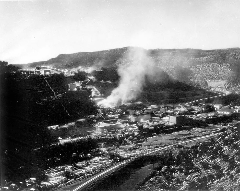
The mill provided employment for miners, truck drivers, equipment operators, chemists, mechanics, clerical employees, and others. Its activities also supported surrounding communities, including Naturita and Nucla.
EPA records indicate that, during its principal operating years, the mill produced approximately 42 million pounds of uranium oxide and 222 million pounds of vanadium oxide.
THE TURNING POINT
Many mining communities declined because their mineral deposits were depleted or mining became uneconomical. Uravan’s employment declined after uranium demand collapsed, but its complete disappearance was largely a consequence of environmental contamination and cleanup.
Uravan was not simply abandoned.

The Environmental Legacy
Mining and milling left extensive radioactive residues, contaminated soil, and groundwater problems. The cleanup required the removal of approximately 260 buildings, including homes, along with dismantling of the industrial operations.
In 2008, the EPA certified major construction cleanup was complete.
In August 2025, the EPA completed its seventh five-year review, finding that the cleanup continued to protect people and the environment. However, radioactive materials remain contained in engineered repositories, and land-use restrictions and ongoing monitoring are still necessary. The next review is scheduled for 2030.
Uravan’s varied and significant history deserves balanced treatment. The economic opportunities it provided the region, its scientific and military contributions, human costs, environmental damage, and the preservation efforts are all part of this town’s story.
THE LAST RESIDENTS
For Uravan’s residents, the mill’s closure meant more than the loss of employment. It meant leaving their hometown.
A former resident and a leader in the Rimrocker Historical Society, Jane Thompson has spoken publicly about her family’s connections to Uravan and the painful loss of the town’s last historic buildings. In Episode 5 of Boom Town: A Uranium Story, Thompson states that her parents were the second to last residents to leave Uravan. She recalls her mother’s love of gardening. As contamination concerns emerged, her mother could no longer eat produce grown in her garden. When her parents ultimately left Uravan, her mother took some of her flower bushes with her.
In 2007, the former boarding house and recreation hall, two buildings that preservationists had fought to save, were destroyed because of contamination and liability concerns.
OUR VISIT
The Road In
We travel south to Ridgway on US Highway 550, then west to Uravan.
Highway 141 provides paved access to the Uravan Ball Park campground site at 22355 Highway 141. It’s well marked and easy to find. It’s maintained by the Rimrocker Historical Society. There we find several interpretive markers and a flagpole flying an American flag. This flagpole once stood across from the post office at the townsite.
We drive through the small campground. It’s peaceful and serene with many sites backing up to the San Miguel River.
Interesting note: The campground sites are named after the lettered blocks of the former town.
I imagine the memories that were made here after work hours and on weekends when residents would meet here.
The annual picnic is held here and guests gather under the pavilion named ‘A Shady Place 4 U.’

First Impression
It’s a small spot in the winding road. The flag flies over the area. There’s not much there. If one doesn’t know Uravan’s history, they’d never know how active the area had been nor the role it played in a significant part of U.S. history.
It’s a beautiful area along Highway 141 and the San Miguel River.
My husband and I have traveled this road many times on his motorcycle, and I’d never noticed the area.
We exit the Ball Park campground onto Highway 141, drive south, then turn onto CR EE22 to find the Superfund site. It’s a dirt-and-gravel road circling the mountainside. As we climb toward the mountain, we’re able to see the entire campground area below us.
WHAT REMAINS TODAY
Before long, we’re traveling along barbed-wire fencing with environmental warning placards. We recognize this area as the former townsite.
Only then do I understand how large the settlement had been—and realize I would not be walking where its streets once ran.
We climb further up the mountain and enjoy amazing views of the valley below and the canyon.
When we reach the top, we’re reminded of what once was. Additional fenced zones marked with yellow warning signs and radioactive symbols amid the scenic surroundings.
The repositories are covered with gray and black rock. Signs of replanted vegetation exist next to the rock-covered areas.
It’s moving.
It feels a bit scary to think about what lies beneath.
WHAT SURPRISED ME MOST?
The complete absence of the residential neighborhood and mining operations at the original townsite.
No surviving buildings. No mill remnants.
Only the Ballpark remains as a recognizable gathering place.
As I look around, it’s difficult to imagine the bustling community described in historical accounts.
There are no residential streets, building foundations, or collapsed buildings to help me imagine what the community had looked like.
No sign of the abundant amenities Uravan enjoyed.
I begin to understand why its former residents are passionate about keeping its legacy alive.
If this had been my home, I’d work to keep its memory flourishing with something tangible. Thanks to dedicated former residents, a museum at 470 Main Street in Nucla preserves Uravan’s legacy.
BEFORE YOU GO
Location: The site is approximately 15 miles northwest of Naturita along Colorado Highway 141. Use the Uravan Ball Park address: 22355 Highway 141, Naturita, CO 81422 for navigation directions.
Elevation: Uravan Ball Park Campground: 4,942 feet. Uravan Townsite: 4,990 feet. Uravan Superfund Repositories (Club Mesa): 5,300 feet to 5,450 feet.
Road / Access: Hwy 141 is a paved road directly to the Ball Park. County Road EE22 up the mountain to the repositories is a dirt road. In dry conditions during our visit, CR EE22 was accessible by our Subaru Outback. Conditions during inclement weather can require high clearance and four-wheel drive.
Recommended Vehicle: Standard vehicle to visit the Ball Park and public viewing areas.
Walking Difficulty: Minimal walking required. Areas near interpretive markers are level.
Best season: Generally mid- to late summer into early fall, depending on snow and road conditions.
Cell Service: Map your route before leaving; service may be unreliable.
Private property: Respect all posted boundaries, restrictions and environmental restoration areas. Remain on public roads.
Weather Concerns: Mountain weather can change quickly; check current conditions before leaving.
Environmental Safety: The former townsite and mill areas include restricted Superfund cleanup property. Remain on established public roads and designated visitor areas. Never cross fences or barriers, enter restricted areas, or disturb the engineered waste repositories. Obey all posted environmental warning signs.
Preservation: Do not remove artifacts or objects from historic sites
Take only pictures.
THEN & NOW
WHAT DID URAVAN LEAVE BEHIND?
While Uravan helped shape the history of our world, today, the former townsite is surrounded by barbed-wire fencing with warning signs where the now-reclaimed land shows no sign of the once-thriving town and mining operations.
High above the townsite on the mesa top/rim of Saucer Basin lies the repository of the EPA Superfund site. This is where contaminated materials from the dismantled mill equipment and town buildings were consolidated with millions of cubic yards of milling waste into engineered repositories.
Buried.

One could say that’s all that’s left of Uravan.
I would say otherwise.
Not every home in Uravan was destroyed. In 1985, house mover Herman Archuleta purchased 65 houses from a Union Carbide subsidiary, offering them for relocation. Historical records confirm that fifteen uncontaminated houses were moved to private property north of Uravan. And some reportedly moved to Montrose.
I recently learned that part of the home of friends here in Montrose originally stood in Uravan. I’ve been inside their house and stood in that very section, never realizing its historical significance.
How remarkable to think that while Uravan has disappeared from the landscape, some of its homes are still providing shelter for families today.
Uravan’s most precious legacy lives in the people who grew up there and those who work tirelessly to preserve the town’s memory.
The old Ball Park remains. Now a campground and a designated Montrose County Historic Landmark, it provides a gathering place for former residents and visitors alike.
It sits along the San Miguel River and offers visitors a chance to enjoy the calm river and Colorado's incredible rock formations.
Some of those surrounding hills attracted interest because of the ore they held.
Today, they attract interest for the beauty they hold.
A remarkable tradition in Uravan is the annual picnic. Former residents hold a reunion picnic at the ballpark. The Rimrocker Historical Society organizes the reunion.
The reunion gives former residents an opportunity to reconnect, enjoy one another’s company, and share memories of Uravan.
I find it an interesting contrast that a community that has no surviving residential streets still maintains a gathering place to remember the town they once lived in.
The ballpark preserves something that mining equipment alone could never tell us—the story of the people who called Uravan home.
THE QUESTION IT LEFT ME
How does a small Colorado mining town that helped shape world history
continue to live on after disappearing from the landscape?
My journey through Colorado's historic mining towns began with Iola, a community that disappeared beneath the waters of Blue Mesa Reservoir. Its residents had no choice but to leave their homes behind.
Now, as I close this season of exploring Colorado's mining history, I find myself in Uravan, another town whose residents had little choice in the loss of their community.
Iola was swallowed by water.
Some of Uravan’s houses were moved to new locations. Other buildings were demolished or destroyed, contaminated materials were buried in engineered repositories, and the former townsite was reclaimed.
Both towns disappeared.
Their histories were different, but the result was the same. The people who called these places home lost the communities they knew.
Yet Uravan leaves me with something more than the story of a town that vanished.
Its former residents still gather at the old ballpark. The Rimrocker Historical Society and others continue to preserve photographs, personal stories, and memories of the community that once filled this canyon with life.
Uravan’s old ballpark is no longer simply a place where residents once gathered. It’s where they still return, sharing stories, and keeping memories alive.
Those stories are what keep Uravan from truly disappearing.
And perhaps that's the answer to the question I began asking at Iola.
Buildings can be demolished. Streets can disappear beneath water or reclaimed land. But a community's history doesn't have to disappear with them.
As long as there are people willing to remember and others willing to listen, these towns still have stories to tell.
And that, perhaps, is why I began this mining town journey in the first place.
LEARN MORE
PREVIOUS STOP: UTE-ULAY
THIS IS THE LAST POST OF THE 2026 SEASON
IN MY COLORADO’S ABANDONED TOWNS SERIES.
Until next season,
Thank you for reading.
May God abundantly bless you and may He always keep you.


Comments