
Colorado's Abandoned Towns Sneffels Ghost Town

Site Visit Date: August 27, 2026
Colorado's Abandoned Towns -- Better Known as Ghost Towns.
Today's Town: Sneffels

At roughly 10,620 feet on the south face of Mount Sneffels, a mining town once clung to this rugged corner of Colorado’s San Juan Mountains.
Originally known as Porters, Sneffels grew from a remote silver-mining settlement into a bustling industrial community often reported to have housed as many as 2,000 people.
Today, finding where those people lived isn’t nearly as easy as the numbers suggest.
On August 27, 2026, my husband, our dog, Harley, and I loaded our Wolverine side-by-side and headed into the high country southwest of Ouray. We’d already gone looking for Camp Bird. This time we were searching for Sneffels. And for the answer to the town’s guiding question:
Can one tunnel change the fate of an entire mountain community?
HISTORY OF SNEFFELS
High above Ouray in Colorado's San Juan Mountains lies Yankee Boy Basin, a broad alpine basin surrounded by rugged peaks, waterfalls, wildflower-covered slopes, and terrain rising well above 12,000 feet. Mount Sneffels dominates the skyline at 14,150 feet above sea level while Sneffels Creek carries snowmelt down through the landscape shaped by glaciers and rich in the minerals that first drew prospectors to these mountains in the nineteenth century.
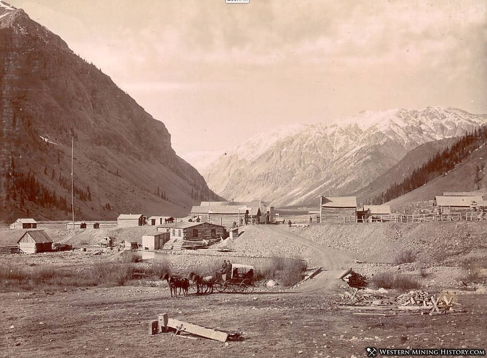
The mining settlement originally known as Porters was established in 1875 on the south face of Mount Sneffels. A post office opened in 1879 under the name Mount Sneffels, later shortened to simply Sneffels in 1895. No single founder is identified, but George R. Porter was an important early merchant/postmaster, and his store/post office appears prominently
in historic photographs.
The rich silver-bearing veins in the high Sneffels, Governor, and Yankee Boy basins created demand for a service and milling center below the mines. The town roughly at 10,620 feet was established. Boom-era accounts commonly place Sneffels’ population at around 2,000 during the height of the Revenue-Virginius boom.
Sneffels supported the mining industry which produced and milled silver with gold, lead, zinc, and copper also produced in the broader district. The rich Virginius Mine lay high above Sneffels in the Governor Basin.
Construction of the Revenue Tunnel began in the late 1880s. Eventually driven roughly 7,600 feet into the mountain, the tunnel provided lower-level access to the Virginius mine and neighboring veins high above Sneffels while also draining water that had made mining in those upper workings difficult. It provided a lower route for moving ore toward the Revenue Mill.

Credit Denver Public Library Special Collections

Revenue Tunnel and Revenue Mill were central. Yankee Boy Mine was nearby in Yankee Boy Basin but was a separate, smaller producer.
The engineering was remarkable. The Virginius workings lay roughly 2,000 vertical feet above the town. Instead of continually hauling ore down from high, avalanche-prone slopes and pumping water from the mine, workers could reach the vein system from far below.
At its peak, accounts describe a community with a school, post office, and even a brass band. Unlike many camps of the era and similar to nearby Camp Bird, the operators provided relatively favorable living conditions, and residents cultivated a remarkably tight-knit community despite the freezing alpine winters.
The settlement supported families and civic life, but surviving documentation is much richer for its post office, general store, boarding houses and mining facilities than for churches and schools.

Credit: Denver Public Library Special Collections, WHJ-943
The historical record gives us names such as George R. Porter, whose store and post office became fixtures in Sneffels, and transportation men whose wagons and pack animals kept the camp connected to Ouray.

But once again, the photographs tell us something the written histories often don't.
Sneffels wasn't populated only by miners.

There were families here.
A school, post office, stores and boarding houses meant ordinary life continued alongside the extraordinary work of extracting silver from the mountain. Photographs preserve glimpses of women and children, yet many of their names have disappeared from the record.
I find myself wondering what winter at 10,620 feet was like for them.
WHAT SNEFFELS DID FOR THE SURROUNDING COMMUNITY
Sneffels became more than a collection of buildings beneath the mines. The Revenue operation created jobs, moved freight and supplies along the mountain roads, supported businesses in Ouray and provided a milling center for valuable ore coming from mines high above the settlement.
Most important, the Revenue Tunnel demonstrated that engineering could make mineral deposits accessible that geography, water, and winter had made extraordinarily difficult to work.
THE TURNING POINT
Ironically, the engineering that helped Sneffels flourish also helped make the town less necessary.
As transportation and underground connections changed, ore did not always need to move through Sneffels as it once had. Production fluctuated, and in 1915 fire destroyed the Revenue Mill.
The mines did not immediately disappear. Mining continued in the district for years.
But Sneffels had depended upon being the place where miners lived, ore was processed and supplies moved through the mountains.
Once that role diminished, so did the town.
By 1930, its post office had closed.
The tunnel had helped build Sneffels.
Changes in mining eventually helped make the town unnecessary.
OUR VISIT
Waterfalls spilled down the slopes beside us. Spruce crowded the lower elevations before giving way to patches of aspen, alpine grass and low shrubs. Above them rose bare rock, jagged peaks surrounding Yankee Boy Basin.
Sporadic tailings and an occasional rusting piece of equipment remain—the few visible reminders that somewhere in all of this, two thousand people had once gone to work, collected their mail, raised families and called Sneffels home.
We couldn't find the town.
That became part of the story.
The mountains surrounding the historic mining district include portions of the protected Mount Sneffels Wilderness, while the old mining corridor itself remains a mixture of public roads, historic claims, and private mining property.
I was amazed at how completely the town itself had disappeared from view even though mining history here isn't entirely over. Nature has reclaimed much of what once surrounded Sneffels, while the privately owned Revenue-Virginius property remains an active-status mining property.
The town may be gone.
The mineral story isn't.
WHAT SURPRISED ME MOST?
That we couldn't find Sneffels.
Not because we didn't know its general location. We did.
What surprised me was that a place once said to hold nearly 2,000 people could disappear so completely into the landscape.
Stores. Boarding houses. A post office. A school. A massive mill. Hundreds of people.
Gone.
Standing there, surrounded by mountains and waterfalls, I kept trying to imagine all those
buildings and all those people living here.
Perhaps that is one of the strangest things about abandoned towns.
Sometimes what isn't there tells the story.
BEFORE YOU GO
Location: On the south face of Mount Sneffels
Elevation: Roughly 10,620 feet above sea level.
Road / Access: From Ouray, follow County Road 361/Camp Bird Road into the high country, then continue onto CR 26/Yankee Boy Basin Road toward the historic Sneffels/Revenue area. Road conditions can change rapidly.
Recommended Vehicle: High-clearance 4x4 vehicle.
Walking Difficulty: Roadside exploration can be limited, but elevation alone can make even short walks strenuous. Remain on public roads and legal public areas and respect all private-property boundaries.
Best season: Generally mid- to late summer into early fall, depending on snow and road conditions.
Cell Service: Map your route before leaving; service may be unreliable.
Private property: Respect all posted boundaries, restrictions and environmental restoration areas.
Weather Concerns: Mountain weather can change quickly; check current conditions before leaving.
Mine / Structure hazards: Do not enter mine openings or climb on unstable historic structures.
Preservation: Do not remove artifacts or objects from historic sites.
Take only pictures. Leave only footprints.
THEN & NOW
Perhaps these were taken facing the same direction. It's difficult to say.


WHAT DID SNEFFELS LEAVE BEHIND?
Sneffels left surprisingly little of the town itself for the casual visitor to recognize.
But its greatest legacy may never have been its buildings.
It was the idea that engineering could change what was possible in these mountains.
The miners above Sneffels faced water, avalanches, elevation and the enormous difficulty of moving men and ore through terrain that seemed determined to resist them.
The Revenue Tunnel attacked those problems from below.
More than a mile of tunnel through solid mountain gave miners another way into valuable veins, provided drainage and helped sustain mining here for decades.
The town eventually disappeared.
The engineering changed the district.
THE QUESTION IT LEFT ME
Sneffels leaves me with the question we started with:
Can one tunnel change the fate of an entire mountain community?
In Sneffels, I think the answer is yes.
The Revenue Tunnel helped turn a remote collection of mines into a major industrial center by solving problems the mountain itself had created.
But Sneffels also reminded me that engineering can preserve a mine longer than it preserves the community built around it.
The mining purpose survived.
The town didn’t.
LEARN MORE
Many Historic Photos Courtesy of: Western Mining History.
PREVIOUS STOP: CAMP BIRD
NEXT STOP: HOWARDSVILLE
What happens when a town is first—but not the town that survives?
[
Thank you for reading.
May God abundantly bless you and may He always keep you.


Comments